Have you ever found yourself tangled in the complex web of land records, wishing there was a simpler way to verify boundaries or track a survey request? For many in Karnataka, the traditional process of managing land documents was once a journey through endless paperwork and multiple office visits. Enter Mojini V3, the Karnataka government’s sophisticated digital solution designed to put land record management directly into your hands.
Whether you are a farmer looking to secure your heritage, a real estate investor conducting due diligence, or a homeowner curious about your property’s digital footprint, Mojini V3 is your primary gateway. This upgraded platform doesn’t just digitize records; it brings transparency and efficiency to the palm of your hand.
What is Mojini V3?
Mojini V3 is the latest version of Karnataka’s digital land survey and record management system, operating under the Department of Survey, Settlement, and Land Records (SSLR). Built upon the robust Bhoomi framework, it serves as the state’s architectural overhaul for spatial data management.
The “V3” represents a significant upgrade from previous versions, offering a more user-friendly interface and improved features for real-time tracking. Its core purpose is to provide an integrated, digital ecosystem for processing survey requests, generating spatial sketches like the 11E and Phodi, and verifying land boundaries to prevent disputes.
Key Features of Mojini V3
The platform is packed with features designed to simplify the lives of Karnataka’s citizens:
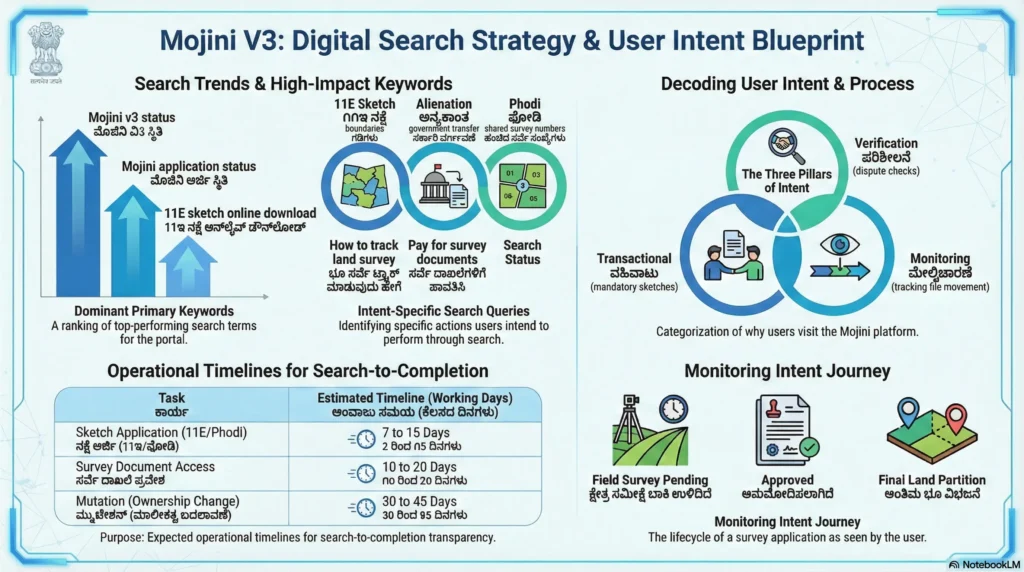
- Application Status Tracking: Real-time updates on the progress of your land survey or sketch requests.
- Digital Sketches (11E & FMB): View and download essential boundary maps and survey sketches online.
- Revenue Map Access: Digitized village and taluk maps are available for public viewing.
- Mobile & Web Accessibility: Accessible via a dedicated web portal and a mobile application available for Android.
- Integration with Bhoomi: Seamlessly links with Record of Rights, Tenancy, and Crops (RTC) and mutation records for a unified experience.
How to Check Mojini V3 Application Status
Checking the status of your application is one of the most used features on the portal. You no longer need to visit a government office to know where your file stands.
Step-by-Step Guide to Track Status:
- Visit the Official Portal: Navigate to bhoomojini.karnataka.gov.in.
- Locate ‘Application Status’: Look for the “Application Status” or “Check Application Status” option on the homepage.
- Choose Your Method: The portal offers three convenient ways to search:
- Application Number: Enter the unique number provided during your request.
- Mobile Number: Use the registered mobile number linked to your application.
- Survey Number: Enter details including District, Taluk, Hobli, Village, and Survey/Hissa number.
- View Results: Click “Get Status” to see the current stage of your file, such as “Pending in Verification” or “Ready for Print.”
Understanding the 11E Sketch
The 11E sketch is a critical document in Mojini V3. It is a pre-mutation survey sketch prepared when a portion of agricultural land within a survey number is being sold, gifted, or divided.
Why it matters:
- It clearly marks the specific boundaries of the land being transferred.
- It prevents future legal disputes by establishing precise measurements.
- It is mandatory to complete the registration and mutation process at the Sub-Registrar’s office.
You can view and download your approved 11E sketch directly from the Mojini portal once the survey process is completed by the assigned surveyor.
Mojini V3 Login and Registration
While many services are available for public viewing, certain actions require a secure login.
- For Citizens: You may need to create an account or use your registered mobile number for specific status checks and document downloads.
- For Professionals: Licensed surveyors and government officials use the portal to upload survey data and process applications.
To login, visit the official site, enter your username and password, or use the Single Sign-On (SSO) ID login if applicable. If you encounter issues, the SSLR department provides a help desk at 08022221038.
Benefits of Using Mojini V3
The transition to Mojini V3 offers several strategic advantages:
- Transparency: Every step of the survey process is logged and viewable by the applicant, reducing the opportunity for corruption.
- Speed: Digital processing and automated workflows significantly cut down the time required for survey approvals.
- Cost-Effective: By providing status updates and sketches online, citizens save on travel costs and manual document fees.
- Accurate Data: Digitized Akarband and spatial records ensure that the land data is accurate and resistant to manual tampering.
Conclusion
Mojini V3 has revolutionized how land records are managed in Karnataka. By moving away from paper-based systems and embracing a real-time digital ecosystem, the state has empowered its citizens with transparency and ease of access. Whether you are tracking a new survey application or downloading a vital 11E sketch, the portal is your most reliable tool for property management.
Take control of your land records today! Visit the official Mojini V3 portal to check your application status or download your property sketches. Don’t leave your land’s digital identity to chance—stay informed and stay updated.