Navigating the varied contours of South India requires more than just a compass; it demands a deep appreciation for a landscape that has been perpetually drawn and redrawn over centuries. For the curious traveller, the dedicated student of the Karnataka Administrative Service (KAS), or the local resident, a precise Karnataka Map is the foundational key to unlocking the state’s potential. From the humid, tropical reaches of the Arabian Sea coast to the sun-scorched, black-soil plateaus of the north, Karnataka offers a geographical diversity that is rare in its complexity and historical depth.
This guide serves as a comprehensive cartographic and historical companion. We shall traverse the evolution of the state’s boundaries—from the fragmented princely domains of the British Raj to the modern administrative structure of 31 districts. We will explore the majestic Western Ghats, the intricate networks of the River Krishna and Cauvery, and the revolutionary digitisation of land records through the Dishaank app. By the conclusion of this journey, you will possess a sophisticated understanding of how Karnataka’s physical and digital maps inform the “near me” search queries that define modern local intent.
From Mysore to Modernity: The Evolution of the Karnataka Map
The Karnataka Map we recognise today is a testament to the Karnataka Ekikarana (Unification) movement—a narrative of a land being “drawn and redrawn” to satisfy the linguistic and cultural aspirations of the Kannada-speaking people. Before 1947, the region was a cartographic patchwork of British presidencies and princely states.
The Political Milestones: 1920 to 1956
The dream of a unified Karnataka was not merely a post-independence project; it found its roots in the early 20th century. A pivotal moment occurred at the 1920 Nagpur session of the Indian National Congress (INC), where the party accepted the linguistic redistribution of provinces as a primary political objective. By 1927, the INC formally suggested that Karnataka, alongside Andhra and Sindh, could form a separate province based on its unique language and traditions.
Influential figures such as Aluru Venkata Rao—revered as the “Father of Karnataka Ekikarana”—worked alongside the Kannada Sahitya Parishat to foster a collective identity. When India gained independence in 1947, the Maharaja of Mysore was amongst the first to sign the Instrument of Accession. At that stage, Mysore was a “Part B” state consisting of nine districts. However, many Kannada speakers remained under the jurisdiction of the Bombay Presidency, the Madras Presidency, the Nizam’s Hyderabad State, and the small, centrally administered “Part C” state of Coorg (Kodagu).
The 1956 Milestone and the Renaming of 1973
On 1 November 1956, following the recommendations of the States Reorganisation Commission (SRC) chaired by Fazl Ali, the boundaries were dramatically shifted. The new state integrated:
- Mysore State: The cultural core and administrative heartland.
- Hyderabad State: Specifically the districts of Bidar, Raichur, and Kalaburagi (formerly Gulbarga).
- Madras Presidency: South Canara (Dakshina Kannada) and Kollegal Taluk.
- Bombay Presidency: The northern strongholds of Belagavi (Belgaum), Dharwad, Vijayapura (Bijapur), and North Kanara (Uttara Kannada).
- Minor Princely States: The integration was further solidified by the merger of several smaller domains, including Jamkhandi, Mudhol, Ramdurg, Savanur, and Sandur.
Initially known as “Mysore State”, the name failed to resonate with the northern districts that had been so vital to the unification struggle. On 1 November 1973, under the leadership of Chief Minister Devaraj Urs, the state was officially renamed Karnataka.
Territorial Sensitivities
Even today, the map contains points of administrative and political friction. The Belgaum (Belagavi) border dispute with Maharashtra remains a significant contemporary issue. Though officially integrated into Karnataka in 1956 based on the SRC recommendations, the presence of a substantial Marathi-speaking population has made this region a sensitive subject for cartographers and politicians alike.
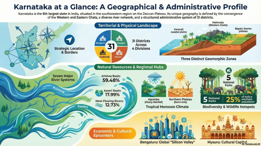
The 31 Districts: Administrative Anatomy
In 1956, the unified state began its journey with 19 districts. Today, that number has grown to 31, reflecting the need for more granular governance as the population and economy expanded.
The 31st Addition: Vijayanagara
The most recent and notable update to the Karnataka Map is the creation of the Vijayanagara district in 2021. Carved out of the sprawling Ballari district, Vijayanagara was established to better manage and promote the world-renowned Hampi heritage sites. Its creation is a classic example of how geography and heritage drive modern administrative subdivisions.
Comprehensive Regional Breakdown
To truly understand Karnataka districts, one must view them through the lens of the state’s four revenue divisions:
- Belagavi Division (North-West): Includes Belagavi, Bagalkote, Vijayapura, Dharwad, Gadag, Haveri, and Uttara Kannada. This region is the gateway to the Deccan Trap.
- Kalaburagi Division (North-East): Encompasses Kalaburagi, Bellary, Bidar, Koppal, Raichur, Yadgir, and the new Vijayanagara district. This is the heart of the “Kalyana Karnataka” region.
- Mysuru Division (South-West): Includes Mysuru, Chamarajanagara, Chikmagaluru, Dakshina Kannada, Hassan, Kodagu, Mandya, and Udupi. This region contains the most dramatic elevations of the Western Ghats.
- Bengaluru Division (South-East): Comprises Bengaluru Urban, Bengaluru Rural, Chikkaballapura, Chitradurga, Davanagere, Kolar, Ramanagara, and Tumakuru.
Historian’s Note: The transition from 19 to 31 districts was not just a bureaucratic exercise but a response to the “different administrative legacies” inherited from the British presidencies and the Nizam’s rule, requiring harmonised land laws and revenue systems.
Physical Geography: Beyond the Lines on the Map
Karnataka sits on the western edge of the Deccan Peninsular region, located between 11.5°N and 18.5°N latitude. Its physical map is a masterclass in varied topography, ranging from sea level to peaks exceeding 1,900 metres.
Regional Landforms
The Northern Karnataka Plateau
Comprising the districts of Belagavi, Bidar, and Kalaburagi, this region is a vast, mostly deforested landscape defined by the Deccan Trap. With an elevation between 300 and 600 metres, its defining characteristic is the treeless expanse of rich black cotton soil. It is a land shaped by the volcanic activity of millennia ago, now serving as the state’s agricultural powerhouse for pulses and cotton.
The Central Karnataka Plateau
Bridging the north and south, this region (including Ballari, Chikmagaluru, and Dharwad) sits at an elevation of 450 to 700 metres. It is defined by the Tungabhadra River basin and serves as a transition zone where the arid north meets the increasingly hilly south.
The Southern Karnataka Plateau
This high-altitude region (600 to 900 metres) includes Bengaluru and Mysuru. It is encircled by the Western Ghats to the west and south. The landscape is marked by residual heights, such as the Biligirirangan hills and the Brahmagiri range, which soar to between 1,500 and 1,750 metres. The Cauvery River basin provides the drainage for this undulating plateau.
The Coastal Karnataka Region
Stretching 267 kilometres along the Arabian Sea, this narrow strip (50 to 80 km wide) is a lush corridor of rivers, creeks, and waterfalls. It encompasses Uttara Kannada, Udupi, and Dakshina Kannada, acting as the maritime gateway for the state.
The 11 Technical Soil Orders
A cartographer’s precision requires looking beneath the surface. While we often speak of nine general soil groups, the technical “Soil Orders” found in Karnataka are much more varied. To understand the land’s fertility, one must recognise these 11 orders:
- Alfisols: Highly productive soils found in the plateau regions.
- Andisols: Volcanic ash soils, rare but present.
- Aridisols: Found in the drier eastern belts.
- Entisols & Inceptisols: Young soils found along river basins and slopes.
- Vertisols: The deep black cotton soils of the north, known for their shrink-swell capacity.
- Oxisols & Ultisols: Highly weathered, acidic red soils common in high-rainfall zones.
- Mollisols, Spodosols, and Histosols: Representing specialized organic and mineral compositions found in forest and wetland ecosystems.
Hydrology: The Seven River Systems
Water is the lifeblood of the Deccan, and the hydrology of the state is divided by the great Sahyadri divide. There are 26 east-flowing rivers that travel towards the Bay of Bengal and 10 west-flowing rivers that plunge toward the Arabian Sea.
The Strategic Value of Water
A striking “Cartographer’s Insight” is that the 10 west-flowing rivers—though much shorter in length—contribute a staggering 60% of the state’s inland water resources. This is due to the immense rainfall captured by the Malnad and Coastal regions.
The seven primary systems are:
- Cauvery (Kaveri): The “Ganga of the South,” vital for SIK.
- Krishna: The lifeline of the northern districts, with major tributaries like the Ghataprabha and Malaprabha.
- Godavari: Touching the north-eastern fringes near Bidar.
- Tungabhadra: A massive system supporting central Karnataka’s agriculture.
- North & South Pennar: Crucial for the eastern plains.
- Palar: Serving the south-eastern drought-prone areas.
- West Flowing Rivers: High-velocity rivers like the Sharavathi, famous for Jog Falls.
Digital Mapping: The Dishaank App Revolution
In the digital age, the “near me” search intent is no longer satisfied by paper maps. The Karnataka State Natural Disaster Monitoring Centre (KSNDMC) and KSRSAC have pioneered the Dishaank app, a mobile-first digital tool that has revolutionised land administration.
Connecting Search Intent to Ground Reality
When a user stands on a piece of land and searches for a “survey number near me,” the Dishaank app utilises GPS to overlay geo-referenced village maps onto satellite imagery. This is the epitome of “Technical Sophistication” in modern cartography.
Key Benefits of Dishaank:
- BHOOMI RTC Integration: Citizens can instantly access the “Record of Rights, Tenancy and Crops” (RTC), identifying ownership and land extent.
- Transparency: It simplifies verifying land details for bank loans, petrol agency permissions, and borewell sanctions, thereby avoiding the legal disputes that historically plagued paper-based records.
- Local Search Strategy: For a resident in Bengaluru or a farmer in Belagavi, this app provides a level of detail—down to the survey parcel—that traditional maps cannot match.
Traditional vs. Digital
To appreciate the modern Karnataka Map, one must compare the various tools available to the public.
| Feature | Traditional Paper Maps | Dishaank Digital Maps | Educational/Exam-Prep (Drishti IAS) |
| Best For | Tactile navigation / Hiking. | Property boundaries / Loans. | KPSC exams / Historical context. |
| Accessibility | Physical purchase / Shops. | Instant mobile download. | Online / PDF modules. |
| Detail Level | Regional / Topographical. | Hyper-local (Survey Number). | Conceptual / Thematic. |
| Update Frequency | Every 5-10 years. | Near real-time digital sync. | Monthly (Current Affairs). |
Tourism and the Historian’s Trail
A map is also a guide to adventure. By understanding the physical geography, one can plan a journey that mirrors the state’s dynastic history.
- The Kadamba Trail: Explore the lush forests of Uttara Kannada.
- The Hoysala Circuit: Navigate the Southern Plateau through Hassan and Mysuru to witness intricate stone carvings.
- The Vijayanagara Expedition: Use a map of the Tungabhadra basin to explore the ruins of Hampi, moving from the river plains into the rugged boulder-strewn hills.
Strategic travel involves moving from the coastal plains (300m elevation) through the Malnad gaps, finally ascending to the cool, mist-covered heights of Kodagu, where the elevation reaches over 1,750m.
Conclusion and Summary
The Karnataka Map is a living document, a synthesis of the black cotton soils of the north and the humid tropical coast of the south. It has evolved from the linguistic redistributions of 1920 to the digital sophistication of the Dishaank app in 2024. Whether you are identifying the 11 technical soil orders, tracking the flow of the 26 east-flowing rivers, or simply exploring the 31 districts, the map remains your most authoritative guide to the heritage of the Kannada people.
As you explore this vibrant state, remember that every boundary line and river bend carries a story of unification and progress. Karnataka is not just a place on a map; it is a meticulously organised landscape of history and innovation.
Frequently Asked Questions
How many districts are currently on the Karnataka Map?
There are 31 districts. The 31st and most recent is Vijayanagara, which was created in 2021 from the Ballari district.
What are the major river systems in Karnataka?
The state features seven major river systems: Cauvery, Godavari, Krishna, North Pennar, South Pennar, Palar, and the West Flowing Rivers.
What is the purpose of the Dishaank app?
Developed by KSRSAC, it allows users to access geo-referenced land survey records, identify survey numbers via GPS, and view BHOOMI RTC ownership details.
What is the mean annual rainfall in the state?
The mean annual rainfall is approximately 1,355 mm, though this varies significantly between the high-rainfall coastal regions and the deficit areas of North Interior Karnataka.